Choquequirao trek 4 Days is an incredible and strenuous trek that will take you to one of the last refuges of the Inca civilization.
The best way to explore Choquequirao is to learn about the history of this site, see the ruins and enjoy a scenic 4-day trek through the Andes.
Visit the other Machu Picchu, the Choquequirao Archaeological Complex and enjoy its natural beauty. choquequirao, choquequirao treks
 Duration: 4 Days Duration: 4 Days |  Altitude: 1.500 – 3.030 m.a.s.l. Altitude: 1.500 – 3.030 m.a.s.l. |  Accommodation: Hotel Accommodation: Hotel |
 Difficulty: Challenging Difficulty: Challenging |  Season: All year Season: All year |
Overview
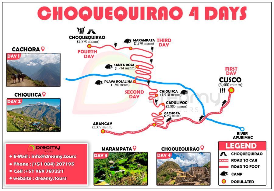
DAY 1: CUSCO – CACHORA – CAPULIYOC – SANTA ROSA
- 6 AM Pickup at your Hotel
- Meals: (optional Breakfast), 1 Lunch, 1 Dinner & Snacks
- Approximate hiking time: ~7 hrs.
- Difficulty: Moderate
- Climate: Warm
- Highest elevation: 2970 m / 9744.1 ft
- Campsite in Santa Rosa
DAY 2: SANTA ROSA – MARAMPATA
- Meals: (optional Breakfast), 1 Lunch, 1 Dinner & Snacks
- Approximate hiking time: ~7 hrs.
- Difficulty: Challenging
- Climate: Warm and Cold at night
- Highest elevation: 3600 m / 11811 ft
- Campsite in Marampata
DAY 3: MARAMPATA – CHOQUEQUIRAO – PLAYA ROSALINAS
- Meals: 1 Breakfast, 1 Lunch, 1 Dinner & Snacks
- Approximate hiking time: ~4 hrs.
- Difficulty: Easy to Moderate
- Climate: Warm
- Highest elevation: 3550 m / 11647 ft
- Campsite in Playa Rosalinas
DAY 4: PLAYA ROSALINAS – CAPULIYOC – CACHORA – CUSCO
- Meals: 1 Breakfast, 1 Lunch, 1 Dinner & Snacks
- Approximate hiking time: ~4 hrs.
- Difficulty: Easy to Moderate
- Climate: Warm
- Highest elevation: 3550 m / 11647 ft
- Transportation back to Cusco
Itinerary
DAY 1: CUSCO – CACHORA – CAPULIYOC – SANTA ROSA
The departure for this trek is early in the morning, northwest of the city of Cusco (3350 m.a.s.l.) by tourist transport to the village of Cachora (2850 m.a.s.l.). Cachora is surrounded by mountains and the majestic snow-capped Padreyoc (5571 m.a.s.l.).
This is the meeting place with the muleteers and their horses, who must carry all the camping equipment along this expedition.
At the moment we start walking with some ecological slopes, we will have the presence of the enormous divinity of Padreyoc in the pass of Capuliyoc (2800 m.a.s.l.).
From Capuliyoc, we will have a spectacular presence of the Apurimac Gorge and part of the archaeological complex of Choquequirao, which, for a short rest, we will observe our way downhill along the edge of the mountain to the camp which will be Chiquisca (1930 m).
- Walking time 07 hours.
- Climate: warm.
- Campsite: Chiquisca.
DAY 2: SANTA ROSA – MARAMPATA
After breakfast.
We start to descend for approximately one hour to La Playa Rosalina (1500 m.a.s.l.). From here, it is the beginning of the climb out of the gorge, in a very hot climate, to the village of Marampata (2850 m.a.s.l.), where we will have a beautiful view of the archaeological complex of Choquequirao.
The phenomenon of the sunset is enigmatic in Choquequirao, accompanied by an Andean symbol, the “Condor”, which descends from the highest mountains of the Vilcabamba range to the archaeological complex of Choquequirao (3033 m.a.s.l.), where our camp will be.
- Walking time: 7 hours.
- Weather: hot and cold.
- Campsite: Choquequirao Archaeological Centre.
DAY 3: MARAMPATA – CHOQUEQUIRAO – PLAYA ROSALINAS
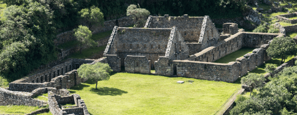
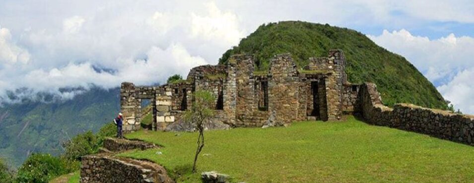
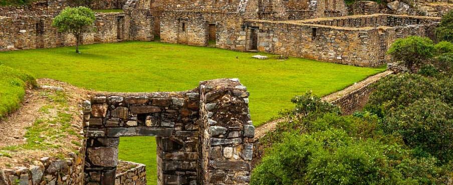
We will observe the sunrise over the archaeological complex of Choquequirao (3033 m. S.N. M), accompanied by a professional guide, you will have explanation about the history, ruins and recent excavations found.
Currently, Choquequirao – Cusco holds many ancestral secrets, as at this moment there are only 30% of the ruins restored, knowing that this important project will be completed and presented to the eyes of the world “The Cradle of Gold” within 10 years.
After the visit to Choquequirao, we will have to leave the main site and take our belongings with us, to go along a road not as common as the usual one visited.
Along this new route we will have breathtaking views, such as the Apurimac Gorge, at its most, the goodness of the flora and fauna. With a slope between Choquequirao and the beach of San Ignacio (1500 m.a.s.l.), deep.
And climb to the camp in a beautiful paradise known as Carmen Huerto (2000 m.a.s.l.).
DAY 4: PLAYA ROSALINAS – CAPULIYOC – CACHORA – CUSCO
El Huerto Carmen is close to the bamba Tambo farm, which in the years of colonization was ruled by the main Hacendados authorities in their regions.
They had presented their servants as slaves and large acres of cultivation. They were very rich in the cultivation of their agricultural produce, livestock, etc.
Nowadays, El Tambó Bamba (2500 m.a.s.l.) offers many natural riches in different areas of agricultural and livestock production, preserving the tradition and knowledge of our Andean ancestors.
Continuing with the tour, we will visit communities such as Pacobamba and Huanipaca (3150 m.a.s.l.).
From the community of Huanipaca, we will find the best impressive view of the glacier chain “Sacsarayoc”, located in the region of Vilcabamba (the last refuge of the Incas).
Afterwards, we will have the transport service that will take us back to the city of Cusco.
We offer you an additional day to enjoy more time in the archaeological complex of Choquequirao and the thermal baths of Cconoc.
On the way back to Cusco, we will stop in Cconoc and have fun in the natural hot springs, with many healing and relaxing benefits.
Included
TOUR INCLUDES
- Bilingual guide service in English or Spanish (language on request).
- Private transportation from Cusco to Cachora.
- Private transportation from Huanipaca to Cusco.
- Entrance to the archaeological complex of Choquequirao.
- Food during the tour.
- Cook and kitchen assistant.
- Shop and kitchen equipment.
- Camping equipment (customer store, mats, dining room with tables and chairs).
- Muleteers and porters.
- Packhorses for camping equipment, food and personal passenger backpack.
- First aid kit and oxygen balloon.
TOUR DOES NOT INCLUDE
- Breakfast first day.
- Sleeping bag.
Contact Us
GENERAL CONDITIONS
- All rates are in US dollars (optional for currency exchange) and are scheduled per person.
- The valid rates for Peruvians only include IGV.
- All our rates are subject to availability and changes.
- Children under 02 years and 11 months are considered INF (babies), do not pay any service and do not have the right to food, bed or seat on tours.
- DCC (child) is considered a child from 03 to 10 years and 11 months, has a special rate and shares a room with parents.
- Children over 11 years considered adults.
- Minors must travel with an identity document.
- Rates do not apply to holidays, Easter, long weekends, national holidays, Christmas or New Year.
More Information
Choquequirao, which is how the archaeological complex is known, is located between the slopes and the top of the hill of the same name at 3104.09 metres above sea level, on what is described as a rocky spur of the Yanama snow-capped mountain.
What does Choquequirao mean?
Choquequirao means ‘Cradle of gold’ in Quechua. It is considered the ‘Sister City of Machu Picchu’, because of its similarities to the Inca City.
In fact, its architecture is as impressive as that of Machu Picchu.
The last Inca capital was established in the Vilcabamba or Antis region, which was the most difficult and inaccessible for the warrior tribes of the 16th century. It has a chain of snow-capped peaks and high jungle mountains, with constantly changing climates.
It is bounded by two of the deepest canyons; the Apurimac Gorge. Crossing the left bank and, on the right bank, the canyon of willkamayu (sacred river), both rivers flow many torrents that carved and sculpted one of the most beautiful and spectacular landscapes of the Andean region.
Did you know that the archaeological complex has been known by two names:
Fortress (Bingham 1953: 142) and ceremonial centre (Samanez and Zapata 1999; also Lumbreras 2001). But these are not the only ones, as since the 17th century it has been given other names, not in the archaeological but in the functional sense, such as: ‘City of the gentility’, ‘Inca’s rooms’, ‘City or town of silverware’, ‘Last refuge of the Incas of Vilcabamba’.
Who discovered Choquequirao?
Like Machu Picchu, many people knew of the existence of Inca archaeological remains at Choquequirao. However, it was Hiram Bingham (the discoverer of Machu Picchu) who in 1909 made the importance of the Inca site known to the world.
Excavation work began in 1970. At present, it is estimated that only 40% of Choquequirao has been unearthed and put on public display.
How is the Inca archaeological site – Choquequirao built?
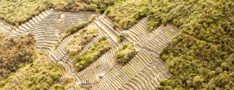
Choquequirao is built on a north-south axis, with a 65-meter height difference between the first and second planes. Each plan has three groups of constructions distributed according to the topographical layout of the terrain.
The central area of the complex, probably ceremonial, is 700 metres long.
Due to the altitude at which Choquequirao is located, altitude sickness or soroche can cause discomfort during the ascent. It is advisable to acclimatize to the climate of Cusco (or Abancay) before starting the trek.
Tips for going to Choquequirao.
*Although you don’t need to be an expert mountaineer to visit Choquequirao, some exercise is recommended before the adventure.
*Due to the altitude at which Choquequirao is located, altitude sickness or soroche can cause discomfort during the ascent.
It is advisable to acclimatize to the climate of Cusco (or Abancay) before starting the trek.
*Unlike Machu Picchu, Choquequirao receives only a handful of visitors per day. It is recommended to enjoy nature and the archaeological site, but with responsibility.
How difficult is the Choquequirao trek?
The trekking route to Choquequirao has a medium-high difficulty. From the village of Cachora to the archaeological site, you walk a total of 31 kilometres one way and 31 kilometres back. The hike includes a descent and a steep climb.
When is the best time to trek to Choquequirao?
The best time to travel is between April and October. Choquequirao has two seasons:
Rainy season (November to March): this is characterized by frequent river rainfall. The sun is not as intense, but the rain can be detrimental to the excursion. Dry season (April to October) is characterized by less frequent rainfall. Days are hotter and nights are cooler. However, the low chance of rain favours the excursion.
What is the climate like in Choquequirao?
The archaeological site of Choquequirao is located at 3,033 meters above sea level. The climate is temperate with cold nights. However, the tourist will not stay in the Inca site until after sunset.
The road leading to the top of Choquequirao is hot due to the proximity of the Apurimac canyon. It is estimated that the temperature at the archaeological site varies between 5º C and 25º C.
What is the flora and fauna like at Choquequirao?
Choquequirao is home to a diversity of animals and birds such as the condor, foxes, viscachas, pumas, hummingbirds, spectacled bears and the cock of the rock. In addition, like Machu Picchu, there is a great variety of orchids.
Price
HOW MUCH?
We have price alternatives that accommodate all budgets, prices per person, expressed in US Dollars.
Make your quotes and reservations by email [email protected], you can also communicate with one of our sales executives at the telephones detailed below, we will be happy to assist you.
Phone – WhatsApp: +51 969 787 221
Phone – WhatsApp: +51 986 994 218
HOW TO BOOK THE TOUR?
To start the reservation process, please send us the following information:
- Name and surname:
- Passport number:
- Nationality:
- Date of Birth:
- Phone:
- Very important – We need the address and information about the hotel that you are staying at, in the city of Cusco, to be able to pick you up at the time when the tour starts.
To confirm reservations it is required to pay 50% in advance and the other 50% can be paid upon arrival at your destination.
PAYMENT METHODS
- IZIPAY
- PAYPAL
- WESTER UNION
- MONEYGRAM
- TRANSFER TO OUR BANK ACCOUNT PERU
Map



 Whatsapp